


ЗАСНОВАНА У 1855 РОЦІ

ЗАСНОВАНА У 1855 РОЦІ


26.09.2025
Про метеорологічну осінь у столиці
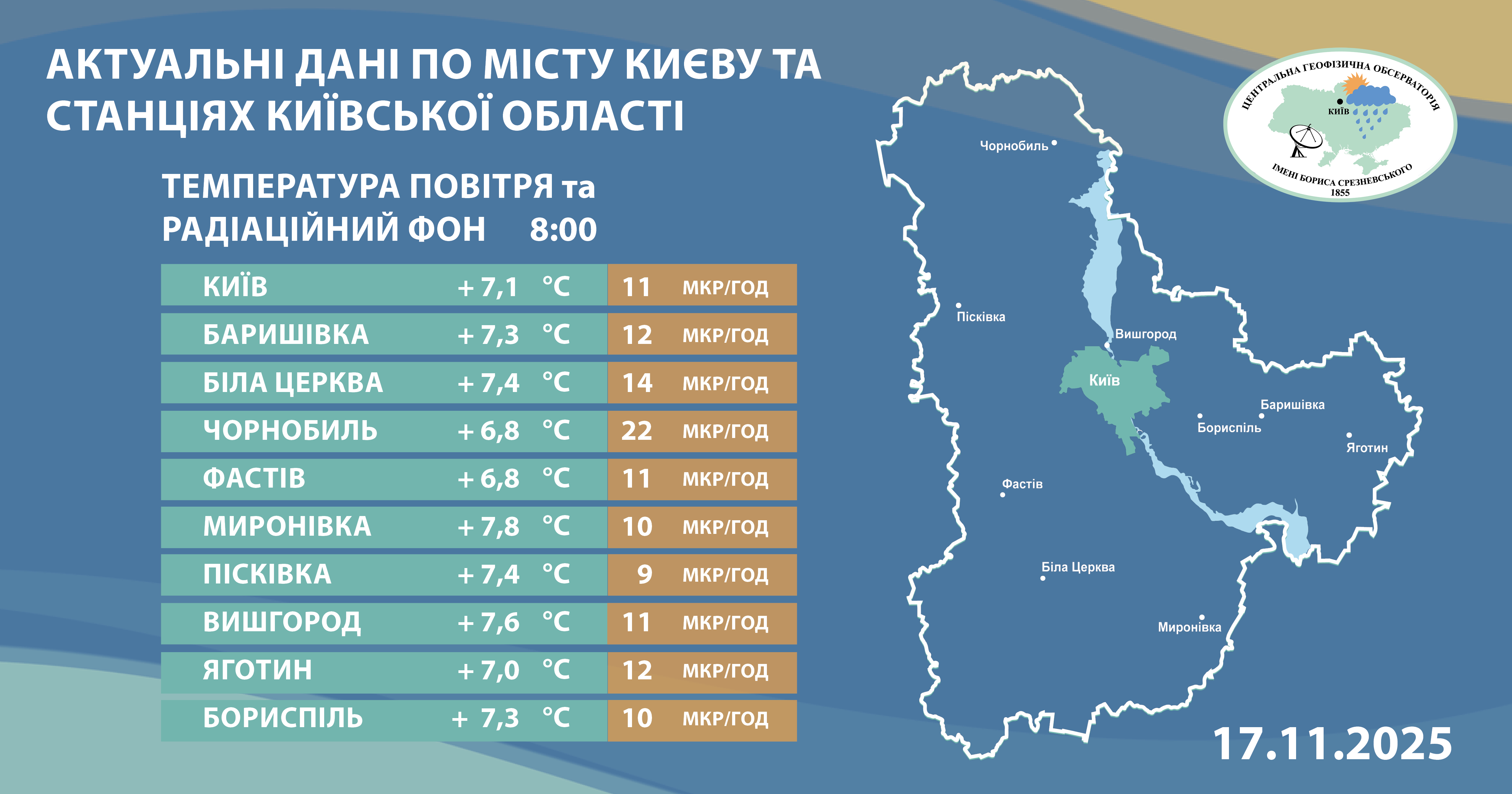
Центральна геофізична обсерваторія імені Бориса Срезневського повідомляє, що за даними спостережень об’єднаної гідрометеорологічної станції Київ 24 вересня до столиці завітала метеорологічна осінь, яка розпочалась на тиждень пізніше за кліматичну норму. Вона характеризується стійким переходом середньодобової температури повітря нижче +15 градусів.
Найраніше метеорологічна осінь до Києва завітала у 1993 році – 25 серпня, а найпізніше – 15 жовтня у 2020 році.
Цьогорічне метеорологічне літо, яке розпочалось 21 травня, закінчилось 23 вересня і загалом тривало 126 днів. Найдовшим літо було в 2012 році – 166 днів, а найкоротшим у 1990 році – 88 днів.
UDC 556.53 (282.247.32)
ISBN 978-966-501-082-1
Scientific edition
Vyshnevskyi Victor
The most important information about the Dnipro River, from its source to its mouth, is provided. Factors of anthropogenic impact are highlighted, including water intake and discharge, flow regulation, channel straightening works, bridge construction, and others. Research results on the river's water regime are presented, covering water levels and flow rates, thermal regime, quality characteristics, and more. Information about the largest tributaries is included. Measures aimed at improving the ecological condition of the river and its watershed are outlined. Key historical and architectural landmarks along the riverbanks are also mentioned.
For hydrometeorologists, water management professionals, nature conservation specialists, local historians, university lecturers, teachers, and students.
CONTENTS
Introduction
1. The Dnipro river and its basin
1.1. General Information
1.2. Hydrographic Description
1.3. Research History
1.3.1. Ancient Works
1.3.2. River Mapping
1.3.3. Leading Institutions in Dnipro Research
1.3.4. Monitoring in the Dnipro Basin
1.3.5. Summary Studies
1.4. Subsurface Structure
1.5. Relief
1.6. Soils
1.7. Groundwater
1.8. Climatic Conditions
1.8.1. Atmospheric Circulation and Wind
1.8.2. Solar Radiation
1.8.3. Air Temperature
1.8.4. Air Humidity
1.8.5. Precipitation
1.8.6. Snow Cover
1.8.7. Evaporation from Water Surfaces
1.9. Forest Cover
1.10. Aquatic and Semi-Aquatic Flora and Fauna
1.10.1. Flora
1.10.2. Fauna
2. Economic use of the Dnipro
2.1. General Characteristics
2.2. Navigation
2.3. Navigable Channels
2.4. Channel Straightening, Dredging, and Bank Protection Works
2.5. Bridges and Underwater Crossings
2.5.1. Bridges
2.5.2. Underwater Crossings
2.6. Flow Regulation
2.6.1. General Information
2.6.2. Kyiv HPP and Kyiv Reservoir
2.6.3. Kaniv HPP and Kaniv Reservoir
2.6.4. Kremenchuk HPP and Kremenchuk Reservoir
2.6.5. Dnipro-Dzerzhynsk HPP and Reservoir
2.6.6. DniproHES and Dnipro Reservoir
2.6.7. Kakhovka HPP and Kakhovka Reservoir
2.6.8. Regulation of Dnipro Tributaries
2.7. Canals and Water Pipelines
2.7.1. Facilities in Belarus
2.7.2. Facilities in Ukraine
2.8. Water Intake and Discharge
2.8.1. Water Intake and Consumption
2.8.2. Wastewater Discharge
2.9. Major Cities and Their Water and Sewerage Systems
2.9.1. Major Cities
2.9.2. Water and Sewerage Systems
2.10. Nuclear and Thermal Power Plants
2.11. Mineral Extraction
2.12. Agricultural Activities
2.13. Land Reclamation
2.13.1. Drainage
2.13.2. Irrigation
2.14. Fishing
3. Operation of the Dnipro reservoir cascade
3.1. Basic Principles
3.2. Operational Regime of Reservoirs
3.3. Flood Prevention and Flood Control
3.3.1. General Characteristics of Protected Areas
3.3.2. Protected Areas in the Kyiv Reservoir Zone
3.3.3. Protected Areas in the Kaniv Reservoir Zone
3.3.4. Protected Areas in the Kremenchuk Reservoir Zone
3.3.5. Protected Areas in the Dnipro-Dzerzhynsk Reservoir Zone
3.3.6. Protected Areas in the Kakhovka Reservoir Zone
3.4. Reservoir Bank Erosion and Protection
3.4.1. Bank Erosion
3.4.2. Bank Protection
4. Water regime
4.1. Water Levels
4.1.1. Conditions of Unregulated Flow
4.1.2. Conditions of Regulated Flow
4.1.3. Intra-Day Fluctuations Caused by Irregular HPP Operations
4.1.4. Surge and Setdown Phenomena
4.2. Dnipro Water Discharge
4.2.1. Average Annual Discharge
4.2.2. Intra-Annual Flow Distribution: Maximum and Minimum Discharges
4.3. Water Balance of the Basin
4.4. Water Balance of the Dnipro Reservoirs
4.5. Flow Transformation
4.6. Dynamic Phenomena in Reservoirs
4.6.1. Currents
4.6.2. Wind Waves
4.7. Water Turbidity and Sediment Transport
4.8. Thermal Regime
4.9. Ice Regime
4.9.1. Ice Phenomena Timelines
4.9.2. Ice Thickness
5. Water quality status
5.1. Hydrochemical Characteristics
5.2. Radioactive Water Pollution
5.3. Hydrobiological Indicators of Water Quality and “Blooming”
6. Tributaries of the Dnipro
6.1. Main Characteristics
6.2. Berezina
6.3. Sozh
6.4. Pripyat
6.5. Desna
6.6. Secondary Tributaries
7. Measures aimed at improving the ecological state of the Dnipro
7.1. Key Problems of the Dnipro
7.2. State Management in Nature Conservation and Improvement of the Dnipro
7.3. Regulatory and Legal Framework in Environmental Protection
7.3.1. General Overview of the Regulatory and Legal Framework
7.3.2. Legal Framework for Water Use
7.3.3. Legal Framework for Economic Activities on Water Fund Lands
7.3.4. Legal Framework for the Use of Fish and Other Animal Resources
7.3.5. Legal Framework for River Alluvium Extraction
7.4. Nature Conservation Measures
7.5. Protection and Restoration of Fish Resources
7.6. Preservation of Valuable Natural Sites
7.7. Historical and Architectural Landmarks Along the Dnipro
Conclusions
References and internet resources
Appendices


Інформуємо всіх читачів, що збірник праць Центральної геофізичної обсерваторії імені Бориса Срезневського віднині зареєстровано як засіб масової інформації, науково-популярне видання (свідотство про державну реєстрацію друкованого засобу масової інформації КВ № 25168-15108 Р від 24.06.2022).
Запрошуємо до співпраці усіх зацікавлених авторів та науковців, які мають напрацювання з метеорології, кліматології, гідрології, гідрохімії тощо, а також історико-краєзнавчих розвідок з життя нашої служби.